Community Resource Identification
INOGO Phase I research taught us that a key component to sustainable growth within the Osa and Golfito cantons, whether of an individual, a community, or the region, is first understanding what resources are available. In this process towards environmental and community sustainability, defining what a resource may or may not be will vary depending on who is asked: factors such as age, gender, education, occupation, and personal experience, to name a few, may all influence how a resource is perceived, valued, and managed. Indeed, the process is collaborative and will take the participation of entire communities, especially those within the INOGO/ACOSA working area.
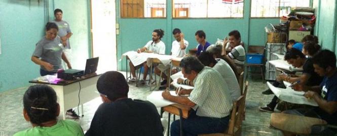
Implementing this knowledge in INOGO Phase II, a small team from Geoporter, a geospatial education organization based in Bahía Ballena-Uvita, Costa Rica recently worked with three communities in the southern region in early October, holding formal technical workshops with participants in community resource identification. Participants ranged in age from youth to elderly community members, and represented men and women throughout the communities of Rancho Quemado, Progresso, and Bahía Drake. In each separate community, the focus of the workshops was to collect and map information from residents about community resources, which will then be used as a baseline assessment for long-term monitoring of environmental stewardship, cultural identity, and safety and security as part of the Caminos de Liderazgo program.
After identifying community assets that align with the goals and objectives of the Caminos program, residents received capacity training to use Global Positioning System (GPS) and Geographic Information Systems (GIS) to map their current assets, being whatever they were and however residents perceived them. This capacity building serves to provide a foundation for residents to use in the future, as they will carry out follow-up data collection within the next few months. Upon further analysis of the collected baseline data, and feedback from participants within each community, INOGO hopes to extend baseline resource identification and mapping to other communities within the region.