INOGO Mapas
Exploring Land Use in Osa and Golfito
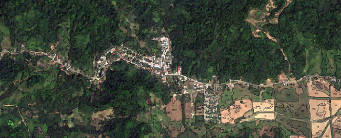
A bird’s-eye view of the Osa and Golfito would tell an interesting story: grazing pastures converted to palm oil plantations, homes being built, roads being paved, and even a better understanding of how different forested areas might connect and form biological corridors.
As a part of the INOGO Phase 1 Terrestrial Ecosystems Component, an in-depth analysis of land use and land cover in the region was undertaken using RapidEye satellite images. This analysis, called INOGO Mapas 2012, is currently in a “beta” (draft) form. INOGO Mapas is based on the prior Ecomapas land use classification, which was produced by INBio in 1998-99. INOGO Mapas is the highest resolution (5x5 m.) land cover classification of the Osa and Golfito region, and likely of almost any study area of comparable size in the world. The map partitions the landscape into more than a million unique polygons with each one classified through an automated process followed by manual verification. This map is virtually cloud free, a feat achieved by using up to eight individual satellite images of the same location to acquire cloud-free viewing of each pixel. In total, INOGO Mapas uses 46 individual RapidEye satellite images, acquired through a custom tasking of the satellite for the INOGO study area during the summer of 2012.
Also view this map on the ESRI ArcGIS website for enhanced features.
The final version this map, and the associated spatial data, is now available to research scientists, NGOs, and any other interested parties. INOGO Mapas provides a high-resolution baseline map of the Osa and Golfito region in 2012 from which to gauge future changes. INOGO scientists are currently working to continue improving and updating INOGO Mapas products in the years to come, with efforts underway to create an updated and improved map for the year 2015 of the region. If you or your organization would like to learn more about INOGO Mapas, including opportunities to collaborate in the improvement and validation effort, please contact Eben Broadbent and Emily Arnold Mest (ebarnold@stanford.edu).
For use in scientific peer-reviewed publications, please contact Eben Broadbent and Emily Arnold Mest (ebarnold@stanford.edu) for collaborative opportunities. For use in reports, please cite: Broadbent EN, Almeyda Zambrano AM, Dirzo RD, Almeyda Zambrano SL, Quispe Gil CA, Morales Barquero L, Villalobos M, Hunt C, Menke C. (In prep) INOGO Mapas 2012: a high resolution map of land cover in the Osa Peninsula and Golfito region of Costa Rica.

Download hyperlinks (shapefiles) - release 12/06/2014
INOGO Mapas 2012 v7 grid 1 (6.5 mb)
INOGO Mapas 2012 v7 grid 2 (2.3 mb)
INOGO Mapas 2012 v7 grid 3 (4.1 mb)
INOGO Mapas 2012 v7 grid 4 (4.6 mb)
INOGO Mapas 2012 v7 grid 5 (0.7 mb)
INOGO Mapas 2012 v7 grid 6 (5.1 mb)
Projection information
Projected Coordinate System: UTM_Zone_17N
Projection: Transverse_Mercator
false_easting: 500000.00000000
false_northing: 0.00000000
central_meridian: -81.00000000
scale_factor: 0.99960000
latitude_of_origin: 0.00000000
Linear Unit: Meter
Geographic Coordinate System: GCS_WGS_1984
Datum: D_WGS_1984
Prime Meridian: Greenwich
Angular Unit: Degree
Land use and land cover map identification codes Download link (Excel version)
| Frequency | Land Use | Code | Notes |
| Very high | Bosque Denso | 1 | |
| Very high | Bosque Denso de Mangle | 101 | |
| Bosque Denso de Melina | 106 | ||
| Very high | Bosque Denso de Palma de Aceite | 111 | |
| Bosque Denso de Pejibaye | 113 | ||
| Bosque Denso de Plantacion Forestal | 104 | ||
| Bosque Denso de Pochote | 108 | ||
| Bosque Denso de Roble Coral | 105 | ||
| Bosque Denso de Teca | 107 | ||
| Bosque Denso de Trichospermum | 103 | ||
| Bosque Denso de Yolillo | 102 | ||
| Bosque Denso Pantanoso | 109 | ||
| High | Bosque Ralo | 2 | |
| Bosque Ralo de Cerillo | 204 | ||
| Bosque Ralo de Mangle | 201 | ||
| Bosque Ralo de Melina | 203 | ||
| Bosque Ralo de Pejibaye | 205 | ||
| Bosque Ralo de Yolillo | 202 | ||
| High | Cuerpo de Agua | 14 | |
| Herbazal Arbolado con Trichospermum | 304 | ||
| Herbazal Arbolado con Yolillo | 301 | ||
| Herbazal Arbolado de Negra Forra | 305 | ||
| Herbazal Arbolado para Forraje | 302 | ||
| Herbazal Arbustivo | 9 | ||
| Herbazal Arbustivo de Palma de Aceite | 903 | ||
| Herbazal Arbustivo de Yolillo | 901 | ||
| Herbazal Arbustivo para Forraje | 902 | ||
| High | Herbazal Denso | 7 | |
| Herbazal Denso Arbolado | 3 | ||
| High | Herbazal Denso de Arroz | 702 | |
| Herbazal Denso de Bamboo | 704 | ||
| Herbazal Denso de Banano | 703 | ||
| Herbazal Denso de Mangle | 701 | ||
| Herbazal Denso de Negra Forra | 706 | ||
| Very High | Herbazal Denso para Forraje | 705 | |
| Herbazal Denso Quemado | 707 | ||
| Herbazal Ralo | 8 | ||
| Herbazal Ralo de Negra Forra | 802 | ||
| Very high | Herbazal Ralo para Forraje | 801 | |
| Very high | Infraestructura | 12 | Roads, houses, urban areas |
| High | Matorral Denso | 4 | |
| Matorral Denso Arbolado | 6 | ||
| Matorral Denso Arbolado de Cerillo | 604 | ||
| High | Matorral Denso Arbolado de Palma de Aceite | 607 | |
| Matorral Denso Arbolado de Plantacion Forestal | 603 | ||
| Matorral Denso Arbolado de Trichospermum | 602 | ||
| Matorral Denso de Mangle | 401 | ||
| Matorral Denso de Palma de Aceite | 406 | ||
| Matorral Denso de Plantacion Forestal | 404 | ||
| Matorral Denso de Trichospermum | 403 | ||
| Matorral Denso de Yolillo | 402 | ||
| High | Matorral Ralo | 5 | |
| Matorral Ralo de Mangle | 501 | ||
| Matorral Ralo de Trichospermum | 502 | ||
| Very high | Terreno Descubierto | 10 | |
| Sombra | 90 | ||
| Nubes | 91 | ||
| Afuera region de estudio INOGO | 99 | ||
| Afuera de imagen RapidEye | 100 | ||
| Bosque Urbano | 115 | ||
| Herbazal Denso Pantanoso | 708 | Freshwater grassland swamp |
No resources found.