Map Library
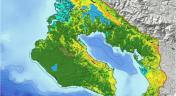
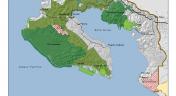
Land Cover and Land Use Map The map below is an interactive GIS map that was created using data regarding land use and land cover change, as well as the prospective future scenarios created by GeoAdaptive. The data was assembled and turned into the product you see here by INOGO...
Published: September 17, 2013
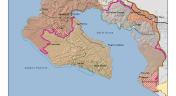
Marine Ecosystem Map The map below is an interactive GIS map that was created using data from the GRUAS II marine and terrestrial ecosystem analysis as well as data from Keto and other marine conservation organizations. The data was assembled and turned into the product you...
Published: September 17, 2013
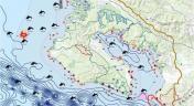
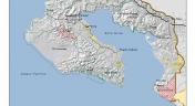
Participatory Mapping Product The map below is an interactive GIS map that was created using the input of 28 experts to prioritize what they consider to be the top three threatened areas (terrestrial). Each was also asked to indicate why they considered these areas to be threatened...
Published: September 17, 2013
Climate and Geomorphology Maps, created by GeoAdaptive, providing graphical depiction of the climate and geomorphological characteristics of the study region.
Published: August 23, 2013
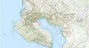
Human Use Maps Maps, created by GeoAdaptive, that show the current and potential types of human use in the Osa-Golfito region.
Published: August 23, 2013
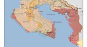
Protected Areas Maps, created by GeoAdaptive, delineating the various protected areas that exist in the region.
Published: August 23, 2013
Land Use Land Cover Change (LULC) Maps Below please find maps created by GeoAdaptive to demonstrate how land use has changed in the Osa and Golfito region from 1985-2011.
Published: August 23, 2013